

The United Nations General Assembly has approved a resolution promoting a world map that shows the relative size of continents more accurately.
The resolution, led by Togo and supported by African countries, passed with 164 votes in favor. The United States was the only country to vote against it, while six countries abstained.
The initiative promotes the Equal Earth projection. It aims to give a more accurate picture of the size of Africa and other continents.
Why the Mercator Map Has Faced Criticism
The Mercator projection dates back to 1569. Flemish cartographer Gerardus Mercator developed it mainly for navigation.
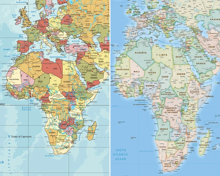
However, the projection distorts the apparent size of land masses. The distortion becomes greater toward the North and South Poles.
More Read

As a result, Greenland can appear almost as large as Africa on common world maps. In reality, Africa is about 14 times larger than Greenland.
Critics have also argued that the traditional map gives a visually larger presence to Europe and other regions in the northern hemisphere.
Equal Earth Map Gains Support
The UN resolution encourages countries and institutions to consider equal-area projections, particularly the Equal Earth map.

The Equal Earth projection was developed in 2018. It provides a more accurate representation of the relative surface area of continents while limiting some of the distortions found in other world map projections.
The campaign is also linked to wider efforts to address the historical and educational impact of distorted world maps.
Togo Leads the Campaign
Togo led the initiative on behalf of the African Union.
Togo’s Foreign Minister Robert Dussey said before the vote that a fairer world should begin with a fairer map.
Togo plans to update its school geography materials by the end of this year. The country also plans to encourage other governments, schools, international organizations and technology companies to consider the new projection.
The campaign organizers say their goal is not to make Africa look larger. Instead, they want maps to show the continent according to its actual geographical size.

US Votes Against the Resolution
The United States was the only country to oppose the resolution.
The US argued that the initiative promotes an ideological agenda and distracts from issues such as international peace, prosperity and global relations.
The resolution is not legally binding. It does not ban the Mercator projection.
The Mercator projection will also continue to have an important role in maritime and air navigation because of its practical properties.
What Could Change?
The resolution could encourage changes in educational materials, media graphics and digital mapping platforms.
Togo and other supporters hope schools, publishers and technology companies will increasingly use maps that represent continental areas more accurately.
The vote therefore marks a significant push for more accurate geographical representation, especially of Africa, while leaving countries and organizations free to choose the map projections they use.